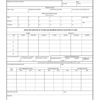
DA Form 5-130. Flood Prediction - Local, Regional, Central
Form DA 5-130 is a Flood Prediction form used for local, regional, and central flood forecasting. The purpose of this form is to record hydrological and meteorological data for predicting and monitoring flood events in specific areas. The form is utilized by meteorologists, hydrologists, and emergency response personnel to assess the potential impact of floods and facilitate timely response measures.
The form consists of sections where various hydrological and meteorological data are recorded, including rainfall measurements, river levels, snowpack data, and weather forecasts. Additionally, it may include sections for observations from local monitoring stations and information on historical flood events. The form is crucial for generating flood forecasts, issuing warnings, and guiding emergency preparedness and response actions.
Important fields in this form include accurate recording of hydrological and meteorological data, including precipitation measurements, river gauge readings, and weather forecasts. Timely and precise completion of this form is essential for effective flood prediction and preparedness, ensuring the safety of residents and minimizing property damage.
Application Example: During a period of heavy rainfall, meteorologists and hydrologists use Form DA 5-130 to monitor river levels, assess the potential for flooding, and issue timely flood forecasts and warnings to local communities. Emergency management officials rely on the data collected in the form to coordinate response efforts and implement flood mitigation measures.
Related Forms: There may be other forms used for flood prediction and monitoring, depending on the specific scope and region. Similar forms may exist within the National Weather Service and other agencies involved in disaster preparedness and response.

