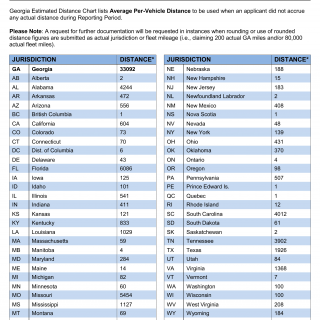
GA DMV Form T-238 Georgia Estimated Distance Chart
Form T-238 Georgia Estimated Distance Chart serves as a tool rather than a traditional form. It is an estimated distance chart used for calculating the distance between two points in Georgia. This chart is utilized for various purposes, including determining travel distances, planning routes, and complying with regulations that require distance calculations.
Form Structure
This chart is not a traditional form with parties involved. It consists of a table or chart that lists various locations or points in Georgia and provides estimated distances between them. It may include cities, towns, or landmarks along with the corresponding distances.
How to Use the Chart
Users can refer to the Georgia Estimated Distance Chart to estimate travel distances between specific locations within the state. It is essential for planning trips, logistics, and ensuring compliance with regulations that require accurate distance calculations. While using the chart, individuals should consider that these distances are estimates and may vary depending on the specific route taken.
This chart is a practical tool for anyone needing to estimate travel distances within Georgia. It is especially useful for truck drivers, transportation companies, and those planning road trips. There may not be direct alternatives, but similar distance estimation tools exist for various regions and purposes.

